For this project, I had to locate possible parcels for a new industrial park in Brockton, MA. In this report I included a map, a table, and a flow chart to show my steps in making the map.
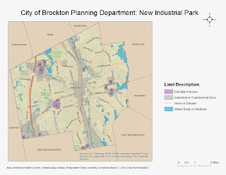
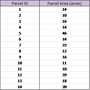
Map Description: This map is showing possible locations for a new industrial park in Brockton. The requirements were that the parcel must be at least 10 acres in area, at least 50 feet from wetland or water, and must already be zoned as industrial or commercial. In the map above the purple represents possible parcels where the new industrial park could be located. The gray represents parcels that are industrial or commercial. All purple parcels are zoned as industrial or commercial as well. A total of 14 parcels are selected as being a possible location for the industrial park. The parcels are labeled on the map and in a table. The table also includes the size of the parcel.
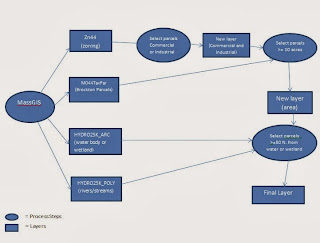
Methods: I created this map in ArcMap, using data from MassGIS. From MassGIS, I downloaded a Brockton parcel layer, a zoning layer, and two hydrology layers. From the zoning layer, I selected all parcels that were categorized as industrial or commercial for general use. I created a new layer based on these results. From that new layer, I selected all parcels that are greater than or equal to 10 acres in area. I then created a new layer from those results. And from that layer, I selected the parcels that are at least 50 feet away from any water body or wetland. I created a new layer from those results, which are shown in purple on the map. These are the selected parcels to be a possible location for the new industrial park.
Data Analysis: A total of 14 parcels are selected as possible locations for the new industrial park, based on the given criteria. However, the planning department may need to consider other site selection criteria. I was given the information that the parcel had to be at least 10 acres in area, but the projected industrial park size should be considered as well. How many buildings are there or will there be? How far apart will these buildings be from each other? If there is a plan for many buildings, then the larger of the selected parcels should be chosen. Location should also be considered. One of the criteria, was that the location had to be at least 50 feet from water or wetland. Other things should be considered, like if it is located along a major road, or close to a residential area. Also, the parcel should not already have an existing business on it. For example, the 3 parcels in the top left of the map are located where there is a mall. So, those parcels would not be suitable for a new industrial park. The parcel should probably be as far away from water or wetland as possible, in order to avoid any water contamination. The parcel along Belmont St. and Forest Ave would be a likely choice for the industrial park. It is not too close to any body of water, and appears to be in a location with no currently existing business. The parcels along the city boundary may not be the best choices if the planning department wants the park more within the city. The parcel near E. Ashland St. is close to a body of water, so that may not be the best choice. The 4 parcels on the right of the map may be good locations. Proximity to residential locations should be considered, because residents may not like the idea of living close to a large industrial or commercial park. If the only criteria would be to have the parcel be >= 10 acres, then there would be many more options. But you could possibly run into issues with conservation and other businesses. If doing this type of assignment with all Massachusetts towns, it would be best to work with all towns at once, instead of doing it one town at a time. That way it would require the same amount of steps. A way to make this map more convenient to use would be to put it into ArcGIS Online and share it or save it as a JPEG and upload it to a website or blog.


