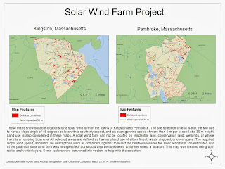
For this project, I had to find all suitable locations for a solar wind farm in Kingston, MA and a town of my choice (Pembroke, MA). The required selection criteria was that the site had to have a slope angle of 15 degrees or less, a southerly aspect slope (135 degrees to 225 degrees), and a wind speed of at least 5 m per second at a 30 m height. I also included land use in the criteria, where the land had to be described as either forest, waste disposal, or open space. I thought these three land use categories would be best for a solar wind farm location.Size of the the solar wind farm was not provided but should also be considered when choosing a location. I used several other raster and vector layers and geoproccessing/spatial analyst tools to come up with a final layer (shown in red on the map) that fits all 3 required criteria.
No comments:
Post a Comment