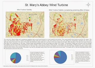
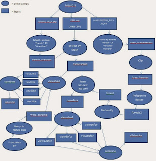
 For this project, I had to find all areas in Franklin, MA and Wrentham, MA where a wind turbine at St. Mary's Abbey in Franklin can be seen. The new wind turbine is 120 ft. tall. The map on the left shows all areas where all or portions of the wind turbine can be seen. This map shows results considering elevation only. The map on the right considers both elevation and the screening effect of trees. Some people may not be able to see the wind turbine if trees are blocking their view. I selected all areas that were labeled as forest or forested wetland and created a separate layer from that. I estimated the forest heights to be about 24 meters. I combined the forest layer with the DEM of Franklin and Wrentham to help create the results shown in the map. There are some flaws with this however. Some forests may have lower tree density or several different tree heights. So in some areas that are considered forested, the wind turbine might be seen in some areas. Below is a flowchart showing the steps I took to make both maps and also the layers and geoprocessing tools I used.

No comments:
Post a Comment