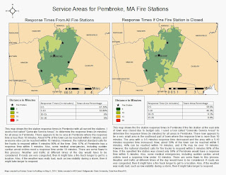
 For this project, I had to determine the response times for fire stations in Pembroke, MA. The map on the left shows the response times if all fire stations are open. The map on the right shows response times if the fire station on the east side of town, near Duxbury, was closed due to budget cuts. As shown in the maps, some people's response times would increase if that fire station was closed. I included tables to show the percentages of total town area and response times. To determine the response times, I used the "Generate Service Areas" tool, which takes roads into consideration. More details are described in the map text.
Monday, May 5, 2014
Service Areas for Fire Stations in Pembroke, MA
 For this project, I had to determine the response times for fire stations in Pembroke, MA. The map on the left shows the response times if all fire stations are open. The map on the right shows response times if the fire station on the east side of town, near Duxbury, was closed due to budget cuts. As shown in the maps, some people's response times would increase if that fire station was closed. I included tables to show the percentages of total town area and response times. To determine the response times, I used the "Generate Service Areas" tool, which takes roads into consideration. More details are described in the map text.
Subscribe to:
Post Comments (Atom)
No comments:
Post a Comment